


190627 - Jura - GdCermoi

randodan
User
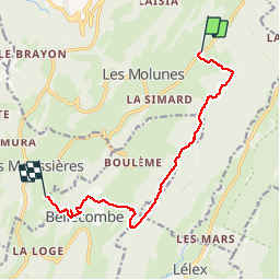

Length
10.5 km

Max alt
1304 m

Uphill gradient
222 m
Km-Effort
13.8 km

Min alt
1158 m

Downhill gradient
320 m
Boucle
No
Creation date :
2019-06-27 07:06:07.52
Updated on :
2019-06-28 06:15:37.596
3h41
Difficulty : Very easy

FREE GPS app for hiking
 SityTrail
IGN / Geographical institutes
SityTrail Plus
The world is yours!
About
Trail Walking of 10.5 km to be discovered at Bourgogne-Franche-Comté, Jura, Septmoncel les Molunes. This trail is proposed by randodan.
Photos


Positioning
Country:
France
Region :
Bourgogne-Franche-Comté
Department/Province :
Jura
Municipality :
Septmoncel les Molunes
Location:
Les Molunes
Start:(Dec)
Start:(UTM)
726523 ; 5137115 (31T) N.
Comments